 Development of Geographical Information System
In the beginning of the 1990s, geographical information systems (GIS) that manage, analyze, and visualize geographical information were expensive and were used only by a limited number of companies and researchers. In addition, their operating methods were complex and not intuitive. While majoring in geography, I started developing software that would turn regional statistic data into maps for my own research. This software, named MANDARA, is a geographical information analysis support system that gained a wide user-base after it became available free online in the 2000s and is currently being used by a wide array of people, including researchers, companies, government and municipal offices, and schools and individuals. I believe that this software has allowed many people to create and transmit their own maps, rather than merely to look at one.
Since the Meiji era (1868–1912), the Japanese government has continually been preparing topographical maps. Past maps are resources that eloquently describe regional changes; however, viewing past topographical maps in general is time-consuming, and paper maps are inconvenient because of their requirements for storage, management, and viewing. This is why we developed chronological topographical map viewing software, Konjaku Map (Past-Present Map), enabling users to freely view past topographical maps by shifting between different times and spaces. This software has also proven useful in many other different fields, including research, education and operation.
We live in an era wherein many people can easily access maps, whether it be a car-navigation system, maps, or online map sites. Further, our society is transforming into one in which individuals can make their own maps and transmit geo-spatial information. Consequently, we have engaged in our research and development in an effort to contribute, regardless of how slight, to such changes.
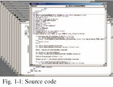
All software is built from a program and, as such, this software, MANDARA, is composed using over 130,000 lines of code. Although programming is a detailed task that requires logical thinking abilities, it feels great when the program functions properly.
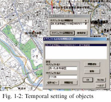 This software, referred to as a “vector type,” perceives map surfaces as assemblies of dot, line, and surface elements. Such software does not treat maps as a simple assembly of pictures and figures but records each element as an “object.” Temporal attributes can be set for each element, and thus, maps can be displayed from an arbitrary period. Additionally, MANDARA can describe hierarchical relationships between objects by using the object-oriented design approach.
 The created map data can be turned into a map by using diverse expression methods in accordance with attribute values.
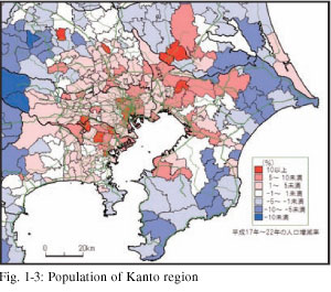
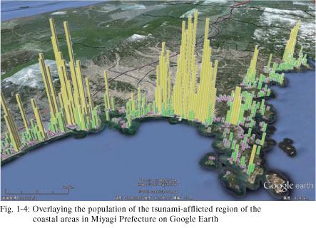 Not only can the software turn data into maps but it can also be crossed with various information to perform tabulation. For example, at the time of the Great East Japan Earthquake, we were quickly able to estimate the population of the tsunami-afflicted regions from 500 m mesh and tsunami inundation images.
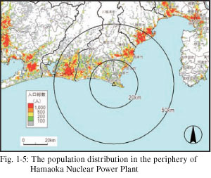
We aggregated the population within the periphery of nuclear power plants across Japan according to the distance from the power plants. This research was introduced in an article of a national newspaper.
Would you like to know how the place you are currently living in looked in the past, or are you interested in buying a house but would like to know how that land was used in the past? Maps are the best tool for knowing the history of the land. Since the Meiji period, the Japanese government has regularly and repeatedly taken measurements, accumulating map records. Although such maps provide extremely effective information, viewing them on the computer as opposed to on a paper-format will enable users to view maps smoothly without issues such as the linkage sections between the temporal changes and drawings.
Konjaku Map 2, developed for this purpose, includes the three major metropolitan areas of Greater Tokyo, Chukyo, and Keihanshin, in addition to over 1,000 past topographical maps of the tsunami-afflicted regions following the Great East Japan Earthquake. As such, this software enables users to shift freely between time and space.
 The above topographical maps around Urayasu City, Chiba Prefecture in 1917 and 2009, as seen in Konjaku Map 2, indicate how the former ocean area had been reclaimed and turned into such facilities as an amusement park, factories, and residential areas within a period of 90 years. During the Great East Japan Earthquake, reclaimed lands, in particular, such as those in Urayasu City experienced extensive liquefaction outbreaks. There have been intensified concerns over past maps for purposes of examination indicating risks of disaster, and the efficacy of the software has been acknowledged for this purpose.
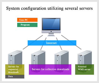
Since a large volume of map images cannot be downloaded in one setting, we have constructed a system wherein necessary data are downloaded and collected from servers every time the display location is moved.
Associate Professor, Social Studies Education Course, the Faculty of Education
Biography
Born in Aichi Prefecture in 1971
After graduating from the Nagoya University School of Letters, he completed his doctorate from the Graduate School of Letters, Nagoya University Graduate School.
After earning his Ph.D. in geography and engaging as a special researcher at the Japan Society for the Promotion of Science, he currently is serving as an associate professor at the Faculty of Education, Saitama University.
Publication
Kenji Tani, 2011, Free GIS Software MANDARA Complete Manual Guide, Kokon Shoin
Kenji Tani, 2009, The Development of the Chronological Topographical Map Viewing Software Konjaku Map 2 (for the Greater Tokyo Area, Chukyo Metropolitan Area, and Keihanshin Metropolitan Area), GIS: Theory and Application, 17(2), 1-10.
Awards
2004: GIS Association of Japan (Software category)
2011: The Association of Japanese Geographers (geography education category) award
Website
http://ktgis.net

 ResearchAdmissionAcademic ProgramsExchange ProgramsStudent Life
© Copyright Saitama University, All Rights Reserved.

 Menu
Menu Home
Home Japanese
 Current Students
 by User
 Contents